LAST DAY Day 35 - June 4 2010
TRIP IS OVER - EVERYONE IS BACK HOME SAFE
I can't believe that the trip is over, having been on the road for 35 days seem like a blur, and some days were a blur.
The trip (route) passed through 20 American States and one Canadian Provence (Ontario) for a total of 11,852KM (7,364.5miles). With every weather condition you can imagine, from snow, hail, dust storms, high winds 75+MPH, and tornado watches to monsoon downpours. But the rest was glorious days, some cool and some very hot 104F (40+C) BUT sunny.
Experienced a lot, meet a number of people on motorcycles doing the same (or wishing they did), as one of my Southern Cruiser friends said to me on Friday on my why home, "there are very few that have done what you (we) did". Ben and I are true Continental Riders and have set a new meaning to "road trip".
Ben and I parted in Lansing, MI, with him heading to Windsor, ON (via Detroit) and I headed due East to the St. Clair River and the last remaining car ferries on the great lakes. Ben was home by 12noon, I was home at 7:15pm. I had a longer trip and Highway #3 in Ontario is not fast, but it was not the Interstate or the 400 series highway ether, so I enjoyed the return trip through Southern Ontario farm country.
Just outside of Port Dover, on Highway 3 I came across an example of "Jewish Lighting" almost first hand, a major restaurant fire at the 18 Wheeler Restaurant, which by the way was for sale (as the OPP Officer said to me "I guess it didn't sell"). It was interesting to watch the Norfolk Country Fire Department set up swimming pools on the highway and truck in water to fight the fire.
Other than a brief stop in Thorold, to say hello to my fellow Southern Cruiser motorcycle members heading out on the Friday ride, I was home at 7:15pm, with most of my neighbours out to see my arrival, did a victory lap of the block with horn blaring.
Karen had prepared a special welcome home dinner for me, and there have been two additional parities hosted by our neighbours in celebration of my return to Niagara-on-the-Lake.
Would I do this trip again - YOU BET! Already working on next years trip, about a 12 to 15 day adventure to the American South on the Natchez Trace Parkway. [http://www.byways.org/explore/byways/2285/travel.html?map=]
KG
Back Home and Retired
Monday, June 7, 2010
Thursday, June 3, 2010
Day 34 - June 3 2010 - Milwaukee, WI to Lansing, MI
Today was a short ride day of about 125miles, PLUS the 400 miles we saved by taking the Lake Express across Lake Michigan from Milwaukee to Muskegon, MI. The ferry followed the old route of the C&O Railway Ferry and the Ann Arbour RR. Big difference this is a hydrofoil and it takes only 2 1/2 hours to cross the lake, vs 5 hours in the old days, but this also saved over a day of riding and we did not have to go through Chicago.
Before taking the ferry we checked out the Harley Davidson museum, this is a fantastic place, even if you don't own a Harley. They have the original Harley #1 motorcycle and some interesting ones from WWII and lots of police bikes as well. A very close friend of Karen and I (Sheila Gale) is writing a book of which the female character called "DOT", is riding a motorcycle, well I found "Dot's Motorcycle" in the Museum (see the photo).
One more day on the road and I will be back in Niagara-on-the-Lake, some 35 days from when I started, bit tired, but a lot wiser, and I have seen so much of the US.
Day 33 - June 2 2010 - Cedar Rapids, IA to Milwaukee, WI
Today's journey will take us out of the Corn Belt and into Dairy Country of Wisconsin, and the rolling hills which were left over from the last glacier period of 10,000 years ago.
And no motorcycle trip through this area would not be complete without a stop at J&P Cycles in Anamosa, IA (http://www.jpcycles.com/) reported to be the world largest after market motorcycle store. I got an H3 headlight bulb, which I had been looking for since mine bunt out 3 weeks ago, yes they had it (pricey at $10.00), store was an experience in itself, we were there for 1 1/2 hours. Lots of bike candy to buy.
We also stopped in at BEAVER, IA, at the post office, open from 7:45AM to 11:30AM, only, this is almost a ghost town, but interesting.
Pushing on east through the rolling hills we passed through Debuque, IA, which was our crossing back over the Mississippi River and our "official" passing from West to East, and also that our epic adventure would soon be over.
As we approached Milwaukee, the monsoon rain hit, with a very fast clothing change under a convenient overpass, I stayed dry, Ben chose NOT to put on rain pants - he paid the price for that. We were about 30 minutes from our hotel for the night, but it seamed like hours, 20MPH, on I-94 and we could not see a thing, made it to the hotel with some dampness around the neck, but BEN was soaked and COLD, we spent most of the night taking his stuff to the laundry mat for drying etc. - Just a very interesting day -
Tuesday, June 1, 2010
Day 32 - June 1 2010 - Fremont, NE to Cedar Rapids, IA
Today the rain chased us East, we never got wet but the showers were close to us for most of the day, except in the afternoon when it became sunny and very humid. It got up to 30C by 4pm, so it was hot!!
We made a brief stop in Omaha to tour through the restored Omaha Union Station, they have restored the interior to what it looked like in 1948 or so, just a wonderful experience. It is also an excellent museum for the city of Omaha. UP RR has it's Headquarters in Omaha as well in a 30 story office tower downtown.
Heading East on I-80 to US59 turning North to pick up US30 East again, this segment of the UP line is double track but very few trains, we only saw two all day. It is nice not be be on the interstate highways, a slower pace, but you get to stop and see things, like the post office in Beaver, IW, only open from 7:30am to 11:30am, but is open on Saturday as well to 10:30am, very small.
Day 31 - May 31 2010 - North Platte NE to Fremont, NE
This Memorial Day in the US, flags everywhere, even on some bikes, but most places are open.
We departed North Platte and followed US30 EAST, which follows the UP Main Line for 250miles to Fremont, NE. There are a lot of trains running today, as well, this is a three track main line so lots of directional movements and overtakes. The UP still likes have trains sitting in sidings waiting and waiting, as well there overtakes are not well staged either, a complex subject which I will not try to explain on the blog.
Most of what we are seeing is unit coal trains heading from and to mid west power plants. These trains are about 100 cars, 2 or 3 engines up front and one DPU (Distributed Power Unit) on the rear, and they roar by.
The landscape changes as well as you move East, soon the sand hills and open range give way to irrigation and corn and wheat farming, with massive grain elevators, much bigger then what we have in Manitoba, as well some of these operations have their own switch engines to move grain cars around.
Also passed several ethanol plants as well, which is what the US is adding to gasoline, our motorcycles don't like this stuff and Ben's bike has some major starting problems with the ethanol mix. We did find that BP has 91 and sometimes 92 octane gas without ethanol.
US30 is also one of the roads which was supplanted by I-80, so you pass by a number of old disused gas stations and a few abandoned motels, almost like Route 66, but it is not the Mother Road.
Some of the farms have large cattle herds, and smell is overwhelming, so to is a 60ft tall pile of fermenting corn, but this is the US mid west.
Day 30 - May 30 2010 - Valentine, NE to North Platte, NE
Bright sunny skies this morning after last night horrific thunder storm and monsoon rains.
We continued South on US83 to North Platte, on the way through the sand hills of Nebraska there was a small Nebraska Sand Turtle making his way across the highway, which was not smart on his part. I immediately stopped turned around and scooped him up from the middle of the driving lane and made sure he safely deposited down the embankment which was his destination.
Today was also a short day (ride of under 100 miles) so we could take in the largest Railroad Yard in the world on the Union Pacific Railroad. There is an 8 story tower built, two years ago, with outside and inside viewing areas, plus a gift shop, bathrooms, and they have retired RR staff to explain what is happening. This yard is 11 miles long by 2 1/2 miles wide, employees 2,500 staff and use 14million gallons of diesel fuel in a month, over 100 trains pass through this place - word is MEGA!! We spent about 4 hours here and left at closing which was 7pm, lots of pictures and about an hour of video. Also taped the intro segment to the Route 66 video as well, watch for its release in the Fall of 2010.
Monday, May 31, 2010
Day 29 - May 29 2010 - Keystone, SD to Valentine, NE
After having a sunny and warm day yesterday (was up to 87F) this day started out cool (45F) and very overcast as we departed Keystone and headed for Rapid City, SD. After a brief stop at the local Kawasaki store for a an adjustment to the throttle, we were off East on I-90 to Murdo. We skipped Badlands National Park because of the gravel roads, motorcycles and gravel don't mix well you know.
Murdo was another place not to spend too much time in, same goes for Wall, SD, both have gas stations and an assortment of tourist traps, like Wall Drug store, with miles and miles of billboards all the way along I-90.
At Murdo one turns South on US83 with the final destination of North Platte, that of course if the weather cooperates, which of course it didn't. We got within 10km of Valentine, NE when the big thunder storm which was moving West hit, the NOAA Weather Radio I carry went ballistic!!, there were 8 Warnings for our area, golf ball size hail, severe lighting, rain 2" per hour (monsoon), winds to 80+ MPH, tornado watch, and very Dark!!!
We arrived drenched at Valentine, but I had moved the reservation to Valentine from North Platte some hours earlier, you don't spend all these years on the road not to be able to read the weather.
Valentine had a very old grain elevator, and was on a 312mile rail trail, which had all the bridges in tack, looked very interesting.
Day 28 - May 28 2010 - Keystone, SD
Awoke, late 8:30, almost missed the deluxe breakfast at the K bar S lodge, which by the way is a great place to stay when in Keystone, as it is away from the "strip" and all the tourists traps in town.
Spent some time chasing the Black Hills Central steam train coming into town from Hill City to Keystone and after that headed for Mount Rushmore for about two hours. For the remainder of the afternoon we set off on some of the best motorcycle roads in the Black Hills, which is US16 and 16A plus the Wildlife Loop in Custer State Park.
We saw wind donkeys and buffalo all over the place, in fact in one location the Buffalo's staged a road block on the loop road, most were afraid to pass these guys, having considerable experience with Manitoba Buffalo and on the recommendation from The HOOT, we took these guys on, and motored right up the middle.
Also of note - did you know it takes a male buffalo over 4 minutes to pee.
Sunday, May 30, 2010
Day 27 - May 27 2010 - Rawlings, WY to Keystone, SD
Today we got a good start out of Rawlings, WY with a brief stop at the Union Pacific RR station with the diesel re-fueling facility built into the two main line tracks, so every train is taking on fuel for the run over the mountains, something to see especially right on a operational sud division. We were also back into full winter gear, as the morning temperature had dipped into the mid 40'sF, we made good progress on US287/WY220 North, and you must realize that there is not much between towns except wide open grass lands, and each town is spaced about 100 miles apart, so fuel up often.
Lunch was in dusty (gravelly) Casper, WY, this was not a place I would go back to.
Taking I-25 for a few miles East to Douglas, where we turned North through Buffalo Gap National Grasslands. We reached Edgemont, SD which in on the BNSF Coal Line, just in time to catch two unit trains of coal heading East, there was a wye here and a branch line of the old CB&Q which ran all the way to Keystone, SD, long since abandoned.
Keystone, SD is a tourist town, much like Niagara Falls is except no waterfall, so what is here Mount Rushmore National Memorial Park - well worth the visit for sure.
Thursday, May 27, 2010
Day 26 - May 26 2010 - Payson, UT to Rawlins, WY
We are heading EAST today, passing through the Provo Canyon, just Southeast of Salt Lake City, stopping a Bridal Vail falls. How come every water fall has the story of the Indian princess who threw herself in the water to create the falls, is that not the story of Niagara Falls?, there are a lot of native princesses out there somewhere, I just hope we don't run out of waterfalls to accommodate them all. The waterfall was extremely beautiful and was worth the stop.
We did a quick tour of Park City, UT, the ski resort town that hosted part of the 2002 Salt Lake City Olympics, before taking the I-80 for 300 miles to Rawlins, WY. The weather was much warmer today, but in the afternoon the winds picked up again, this time the gusts were from behind. Wyoming is open, there was nothing in site for 200+ miles, that was the visibility today, under overcast skies.
Stopped for lunch in Evanston, WY, which is the first town of any size as you enter the state. Spent about 20 minutes down at the RR Station, timing was perfect to see UP Hotshot Double Stack train the "Denver - Z" (zee to the America's), go by with about 40 cars and locos at both ends. Video only on this one.
Continuing East I came across an entire sub division of two story homes, about 40 or so - TOTALLY ABANDONED. Very spooky, I think this was a community of homes directly linked to a non operating mine.
At Creston, WY, I stopped for about 30 minutes for a East Bound UP Drag Freight to catch up, why you ask, it had new GO Transit Engine #637, in the 3rd unit position, brand new heading for Toronto from Boise, ID where they are made, like a break-in run, very cool to see especially as the winds were up to 40MPH, so on the video that is all you will here is the wind.
Arrived in Rawlins at 6PM on the dot - another long day, but no complaints.
Wednesday, May 26, 2010
Day 25 - May 25 2010 - Ely, NV to Payson, UT
After spending some time at the Nevada Northern Railroad yards and shops in Ely for about an hour, they have some very interesting and old equipment, like:
1907 Rotary Plow (wood sides - steam powered)
1917 Jordan Spreader
2 operating steam locomotives
several diesels and an assortment of rolling stock, all operational and running on weekends in the warmer weather.
We continued East on US50 for Payson, UT. See the snow falling in the mountains as we traveled on this highway.
We stopped in Baker for Gas, as the next station was passed our operational range, 250km, and we were not sure of gas a Border, UT (on the NV UT State Line), also had lunch there as well, only one car went through town in 60minutes!!
So we have now done the Loneliest Road in America.
After leaving Border, UT we continues 200km to Delta, UT, more gas again before taking some of the ranch roads which are interesting with cattle and sheep on the road, remember this is OPEN RANGE, so no night riding!
Got to Payson at 5:30pm, now on Mountain Daylight time.
Day 24 - May 24 2010 - Fernley, NV to Ely, NV
We are off on the Loneliest Road in America, US#50 from Fernley to Ely, Nevada.
Got away at 8:21 and arrived in Ely at 4:20pm, not bad for stops and hundreds of photos. The weather as OK, we had snow falling on us as we neared Ruth, NV, which is the largest copper mines and one big hole in the ground, just outside of Ely.
In every town you pass you need to get your US50 passport stamped, upon completion of the 5 stamps (BTW Baker is the last point), you get a certificate from the Governor of Nevada that you survived US50. It was a very COLD trip those 290miles, never got above 40F the whole time.
The key is to gas up in every town you come too.
Day 23 - May 23 2010 - HOLDING IN Fernley, NV
We are HOLDING in Fernley, NV, too much snow on US#50 to make it to Ely, NV, which is about 290miles East of here.
US50 between here and Ely is called the Loneliest Road in America, and is a must do road if you are on a motorcycle. There are only 3 towns on the route, so Gas is 80 to 100 miles apart from that and NO other services, except for the Owl Bar in Eureka. (Which is a must stop).
Here is a picture of The HOOT out front of the Owl Casino, by the way it has an excellent restaurant, the bar allows smoking as do most in Nevada.
The HOOT is along to provide navigational advice and makes the rare appearances at places he likes, so the Owl is one of those special places for him, he a bit shy, and prefers night time activities.
Tuesday, May 25, 2010
Day 22 - May 22 2010 - Jackson, CA to Fernley, NV
This day started out bright and COLD, with the morning temp just slightly above freezing. We continued north on CA#49 with the option of taking US#50 over the mountains into Nevada. This worked, US50 had NO restrictions but we knew that there had been snow overnight on this section as well.
We stopped at a very nice coffee shop in Placerville, CA which included live music, so you can't beat that. After that stop we set out on Highway 50 East to Nevada and Lake Tahoe. We very briefly stopped in Tahoe as we had lost a lot of time using this route. We descended into the inland valley of Nevada on the famous Kingsburry Grade road, which drops over 3,000ft to the town of Gardnerville, NV. There was snow on the side of the road and temperature was now again a 32F or 0C, it made of a very interesting ride on two wheels.
We stopped for lunch in one of my favorite towns, which I have been to so many times, but it was much more fun to arrive on a motorcycle in Genoa, NV. Site of the oldest waterholes (Bars) in the state, and yes there were other bikes there too. After lunch we were off to the REI store in Reno to by more winter clothing, like long john's and glove liners.
After our stop in Reno buying the last of the winter stock we headed for Fernley, NV our overnight stop.
Day 21 - May 21 2010 - Merced, CA to Jackson, CA
Today we are heading for Yosemite National Park on the West side of the Sierra Nevada Mountains. As we climbed from the San Joaquin valley towards the park the temperature started to drop so more clothing was added as we proceeded East to Mariposa, CA and our final destination of Yosemite.
This had to be one of the best times to visit Yosemite as ALL the waterfalls were running, due to the snow melt and the fact that the North and West sides of the park are still closed due to snow, in some spots 11ft deep. We had an enjoyable ride through the park and stopped at all of the vantage points. (see Half Dome Above)
With Hwy#120 closed due to snow, we continued North on CA#49 following the gold route of 1849 through some historical towns of Goveland, Angles Camp and Chinese Camp.
We chose Jackson for the overnight stop as it was at the junction with CA#88 which was an open road over the mountains to Nevada. However, overnight there was snow on #88 and it became a non motorcycle road very quickly.
Sunday, May 23, 2010
Day 20 - May 20 2010 - Santa Cruz, CA to Merced, CA
We departed the CRUZ at 9:30AM, Ben returning to Holister to get his Corbin Trunk back, it was repaired overnight and I headed for the 300+ shops of the Gilroy Factory Outlet mall to check out some kicks from DC Skate.
For once it was not raining and the temperature was about 25C which was very pleasant, plus light winds too.
We both meet up on the road (not planned) CA #162 which is a 4 line 65MPH highway just East of Gilroy, so we traveled into the San Joaquin valley which is very dry and flat, but there are some very impressive irrigation systems including canals etc. This is a big farming area with lots of farms all pumping water onto the fields.
Our overnight stop is in Merced.
Day 19 - May 19 2010 - Santa Cruz, CA
This is a non travel day for us, I am having my Vulcan Motorcycle in for an oil change at the local dealer in town and Ben went off to Holister, CA (about 5o miles South of here) for a problem he is having with his saddle bags.
In the afternoon I explored the downtown and the local surf shops.
Just took it easy in the CRUZ.
In the afternoon I explored the downtown and the local surf shops.
Just took it easy in the CRUZ.
Day 18 - May 18 2010 - Cambria, CA to Santa Cruz, CA
Our Motel in Cambria provided a Continental breakfast delivered to the room which was delightful. After breakfast we departed our ocean front location for the PCH (Pacific Cost Highway) and Big Sur.
The road was fogged in most of the way, and with all the hairpin curves it took about 2 1/2 hours to go about 60miles, you just could not see a thing more than 40ft in front of you. Positive point - not a lot of traffic on the highway, a group of Harley riders passed us on the highway.
We stopped in Big Sur for lunch at the same place that Karen and I had lunch, LOMA VISTA, see the photo on the side bar under CA Coast. Shortly after lunch weather improved and the fog lifted and the sun came out for the last 60 miles to the CRUZ.
Santa Cruz had not changed much in a year, still the laid back town of the mid 60's, my kind of place.
Friday, May 21, 2010
Day 17 - May 17 2010 - Santa Monica, CA to Cambria, CA
After our arrival in Santa Monica and spending the evening on the famous Santa Monica Pier, including a Mexican seafood restaurant, it was time to head North on California 1 or the Pacific Coast Highway (or PCH), with our destination in the beach town of Cambria which is very near the Hearst Castle.
However, this morning it was raining and there was fog as well, but we pushed on, after the dust storms and high winds of the past two weeks a little rain will not slow us down, we did take this section a little slower.
Stopped at Santa Barbara for lunch and gas at Cayucos, we did arrive in Cambria by 5pm, which was not bad considering we didn't leave Santa Monica until 10am.
Cambria is one of these out of this world sea side towns, everything is perfect, our motel was right on the ocean, and we found a vegetarian restaurant called Robin's in town so that is were we had dinner and it rained again.
Day 16 Santa Monica - Sunday May 16
One word says it all "WE MADE IT", 6,017km ALL the way from Niagara-on-the-Lake, Ontario to Santa Monica, California.
On one of the oldest highways in the US; Route 66, and by Motorcycle noless.
More on this last day in this EPIC adventure.
We are tired and we have had too much to drink, so a blog update would not be good. More to follow. Ken and Ben
On one of the oldest highways in the US; Route 66, and by Motorcycle noless.
More on this last day in this EPIC adventure.
We are tired and we have had too much to drink, so a blog update would not be good. More to follow. Ken and Ben
Monday, May 17, 2010
Day 16 - May 16 2010 - Barstow, CA to Santa Monica, CA
This will be our last full day on Route 66, the last few days have gone by really fast and our adventure across the US on Route 66 is coming to an end.
We departed Barstow, but with a stop at the BNSF (ATSF) railroad station which has been restored and it too had a Harvey House, not used but in excellent condition. There is a Route 66 museum and a Western Railroad Museum. You can see that at one time there were 7 passenger tracks in front of the station.
By 10:30 we were underway and the temperature had started to climb into the mid 90'sF, as we headed now South to Victorville on old Route 66, passing by what may be the one of the largest cement plants in the USA, just north of Victorville.
After a brief stop in Victorville it was on to I-15 for a fast downhill run in to San Bernardino, there is a lot of traffic in the greater LA area, but it moves at +65MPH (104KMH). We did exit onto Route 66 at the extreme Eastern end of LA, and stopped the California Wigwam Motel and spoke to the owner and took some pictures. I think there needs to be a patch "I survived I-10", there are some very poor divers in the LA area.
We were informed at the Wigwam, that is was 4+ hrs to Santa Monica following old 66 or a bit over an hour on I-10, we took I-10 as it was already 3pm. After a brief shopping stop on Melrose Ave (Beverly Hills) for some really tricked out kicks (sneakers) at Ed Hardy (http://www.donedhardyshoes.com/) and a few t-shirts from Affliction Clothing (http://www.afflictionclothingstore.com/) it was time to make tracks down the famous Santa Monica Blvd, for the last 4 miles to the pier.
Yes, we made it all the way!! This was an EPIC adventure, and a perfect way to start my retirement. I will not say the trip was easy, but looking back it was great, now we had some mechanical issues with Ben's bike, but so!, and we were separated for a day while Ben was getting his bike fixed and I pushed on into New Mexico. The weather this time of year will always be an issue, but it beats the 100+F heat of Summer in the desert.
At some point I will publish the motels we stayed at, if anyone else wants to duplicate this adventure you will have all the data.
We also found out that our bikes are now running smother than ever before, maybe they are now really "run in". We also had our share of "crap gas", and had to use our booster juice in the tank to keep us running.
Day 15 - May 15 2010 - Kingman, AZ to Barstow, CA
We departed from Kingman after a brief stop at Walmart to pick up a bag of carrots and apples for the wild burrows of Oatman, AZ. Oatman is a fun place to visit, an authentic old western town with wild burros roaming the streets and gunfights staged on weekends. The burros are tame, they to get very excited when you feed them. So I hired a "security burrow" to protect the food and to keep the others at bay, it is very hard to get good staff these days and the working conditions are very dusty. One burrow attempted to eat my flag pole on the bike and stripped the device, so that has to be replace, one attacked my voice recorder and put a dent right through the battery, these guys are tough. The Hoot refused to come out of the trunk box the whole time we were in Oatman.
Start of the Mojave Desert Segment
Next stop is the desert town of Needles, California, yes we have made it to California, and the heat, up to 115F by 2:30 in Needles. So after a gas stop and a "re-water" stop we are off on old Route 66 via Goffs Road and the ghost towns of Goffs, Essex and Cadaz. Cadaz is the home of the famous Road Runner Resort (cafe and gas station), which has been abandoned for years, the cafe is on my main page of this we site.
The real jewel is in Amboy - ROY's MOTEL and CAFE. The site of more photo shoots, TV commercials and full length films, pictures will be posted shortly. But Roy's has GAS and cold, what more do you need at 115F, the desert is just EPIC!!
As the sun was going down and it was 6PM it was time to get moving to Ludlow, and I-40 into Barstow, but in Ludlow there were two more BNSF trains to photograph, so as a result we arrived well after dark around 8:30pm, and very HOT and tired as we did the last 35miles on I-40 at 75MPH.
Day 14 - May 14 2010 - Grand Canyon to Kingman
We got an early start around 9:30, OK Early for us. We had one or two stops to make in the park along the canyon rim before heading South to Williams, AZ. We departed the park in full winter gear, as the overnight temp was around +2C and by 9:30am around +8C, by the time we arrived in Williams it was up to +18C, so off with the Winter gear, much of the trip has been extremes ever in wind or in temperature.
Made a brief stop in Williams to take a look at the old Harvey House at the Williams Station which is now the hotel for the Grand Canyon RR.
On to Ash Forks, the flagstone capital of the US, they cut rock slabs into Flagstone, lots of Flagstone, too.
Just West of Ash Forks is the start of the longest untouched parts of old Route 66, which is about 128miles from there to Kingman. Old 66 crosses over the BNSF RR line just to the East of Seligman there was a East Bound double stack coming so we waited to get it on video before arriving at the Rusty Bolt in Seligman. [http://www.rustybolt66.com/] Check out this very cool place on Route 66. We were there for about 30 minutes before sitting off West bound. Next stop would be Grand Canyon Caverns.
Started looking for gas in Peach Springs, NONE so 7 miles down the road to Truxton and an old service station with regular unleaded, our bikes need 91 premium gas, so we added the octane boost to our tanks and we are good to go. Ben is still having a starting problem with his bike, which I think is related to "bad gas".
Our last stop before Kingman was of course at the Hackberry General Store in Hackberry, AZ, we were there for close to an hour. I had to play with Max and Molly who are the two very spoiled resident (inside) dogs. Max was abandoned by someone (thrown out of a car window), so at 9 he is a bit slow, but I love this guy so much it was very hard for me to leave.
We arrived in Kingman at +31C so the heat of the desert was "ON".
Saturday, May 15, 2010
Day 13 - May 13 2010 - Flagstaff, AZ to Grand Canyon, AZ
Ben's Suzuki C109 motorcycle continues to have starting issues, so this morning it is in the shop in Flagstaff, while I am spending some time at the BNSF (ATSF) depot in downtown Flagstaff.
There was a lot of train traffic overnight, as we could hear them go by, but again like yesterday the traffic dies down, I suspect that there is a work block on the line so only a few if any trains are moving, this is common practice during the Summer months to get track maintenance done. But there were 3 East Bounds and only one West Bound.
Ben's bike was operational just after 1pm, so we made a fast ride up US180 from Flagstaff to the Grand Canyon, the temperature starting falling as we motored North and by the time we reached the canyon is was cold!
We had a enjoyable time along the rim, using the shuttle buses to go from point to point. We watched the sunset at Hermits Point, and made the second to last bus back - in total darkness, we were the last people left in the entire 7 miles on rim road. Also don't believe the signs that buses run to 11pm, there are no buses after 10pm - that was a bit of a problem.
We had dinner in the famous El Tovar Hotel Dining room, and of course missed the last bus back to our lodge, we got a ride in a staff van. All just part of another day out on Route 66.
Thursday, May 13, 2010
Day 12 - May 12 2010 - Gallup, NM to Flagstaff, AZ
Well the winds have subsided, but we are now facing below freezing temperatures in the morning, but it warms up to 10C (50F) by 9AM or so. We left Gallup, New Mexico around 9AM and continued heading West on Route 66 and sometimes we were forced to us I-40 for parts.
This day was a short distance day, with most of it spent at the Petrified Forest National Park in the East side of Arizona. The painted desert is just so beautiful it was hard to keep moving, see photo.
After a brief lunch stop in Holbrook and a photo of the Wigwam Motel on Rt 66 it was off to Winslow for our opportunity to stand on the famous corner in Winslow, AZ, after the prerequisite photo stop and some 40+ photos later we are off again, heading in a headwind, but this was mild compared to what we faced yesterday.
Next stop was Twin Arrow Road and the abandoned gas station of Twin Arrow's, but wait - these are brand NEW arrows, so is someone putting money back into the place, maybe there is a future in Twin Arrows.
The rain started as we left twin arrow's but lasted only a minute, but it has turned COLD, 8C (45F) and as we approached Flagstaff from Winona there was hail that too lasted only a minute. Anyway we were glad to be off the bikes and inside at the Best Western Pony Soldier Motel.
Footnote:
(I have added this as I have found out that a lot of people have never heard of the "Standin' on the Corner in Winslow AZ")
The "Standin’ on the Corner" Park Located in downtown Winslow is "The Corner", made famous by the song "Take It Easy". Written by Glenn Frey and Jackson Browne, "Take It Easy" became The Eagles first hit single in the 70's, and peaked peoples interest in Winslow. The verse "Standin' on a corner in Winslow, Arizona," draws visitors from far and wide to stand on the famous corner. The "Standin' on a Corner" Park is located in historic downtown Winslow and features a life size bronze statue and a two story mural depicting the story behind the famous song. Be sure to read the inscribed bricks that pave the park!
Tuesday, May 11, 2010
Day 11 - May 11 2010 - Santa Fe, NM to Gallup, NM
We departed at 8:45 from Santa Fe, sorry to leave this wonderful place. We headed down NM#14 the famed Turquoise Trail Bi-way and the site of the move Wild Hogs in the town of Madras, it was great experience and it was sunny and warm around 20C, but that would change.
Once we had lunch in Albuquerque the winds were back, but this time with a twist, see this Highway Patrol image from I-40 near Winslow, AZ.
We had winds of 45MPH and gusts of over 65MPH, and the dust and sand was unreal. I have never experienced anything like this, you can't see!
We got into Gallup at 5:30pm and were so glad to be off them for the day.
I-40 has been closed all afternoon from Flagstaff to Winslow, due to blown over tractor trailer trucks (more than one). Also there is NO report of this road opening anytime soon, so our trip is now two days behind if we can't get through. Lots of people are hold up here in Gallup, oh one other interesting weather event - it might snow tonight as the temp is now 29F (-3C) at 10PM.
But the scenery is enchanting but it is New Mexico.
Day 10 - Mon May 10 2010 - Santa Fe, NM
Day 9 - Sun May 9 2010 - Tucumcari, NM to Santa Fe, NM
Sunday started with clear blue skies little wind but cool temperatures, around 8C (42F). I waited for Ben to catch up with me at the Hotel in Tucumcari and we headed off around 10:30am. Our first stop was at the Blue Swallow Motel (ca. 1940) with dial phones. The owner showed us around for about 45 minutes and told us about a great Motorcycle road to Las Vegas, NM, which was our lunch stop.
I recommend NM#104 from Tucumcari to Las Vegas, it climbs to 6,800ft and the zero traffic, we saw 10 cars in 100 miles.
Spent considerable time at the old Harvey House at the Las Vegas station, I need about $15million to put this Jewel on the map again .
After lunch at a Mexican cafe (packed with people), food was very good, we pushed on another 60 miles to Santa Fe, with high winds and gusts over 35MPH, this made the last hour hellish for sure and we had no option but I-25 for about 50% of it.
We are staying at the Old Santa Fe Inn, out of this world place, very old, but with WIFI and very elegant rooms, we have a Junior Suite by the way, with fireplace.
Monday, May 10, 2010
Day 8 - Sat May 8 2010 - Elk City, OK to Tucumcarie, NM
On Saturday, Ben was towed to Oklahoma City (about 120miles East of Elk City) and I pushed on by myself to Amarillo and on to Tucumcari, MN for the night (just like in the old Route 66 days "Tucumcari Tonight" signs are still up.
Stopping at some great locations on the way such as the Leaning Water Tower and the old Texaco Gas Station in Anreed, TX. Spent about 20 minutes at the Big Texan Motel to get some pictures and make my reservation in Tucumcari.
Stopped at the midway cafe (closed) and did get a picture of the midway point sign on Route 66.
Living on the edge it was time to test ones straight (who is afraid of ghosts anyway), by stopping at the ghost town of Glenrio, TX, this time on the TX NM border. Stopped here with by Brother in 2001 and found a vintage vending machine, this time I found the "real" state boundary marker, and no one came out to murder me or for that matter talk.
The push was on to do the next 45 miles and get to the Hotel to do laundry and have a swim in the pool.
Ben's bike was fixed by 4pm and he made to the 180mile dash to Amarillo and the Big Texan Motel.
Day 7 - Fri May 7 2010 - El Reno, OK to Elk City, OK
Day 7 - May 7 2010 - El Reno, OK to Elk City, OK
This day was to be our early start day, like get going at 7AM. Wrong - We left at 7AM to face 45 to 55MPH winds, got 16 miles West of El Reno and returned to the McDonald's as they have wifi so we can get weather forecasts and sat it out to 10:45am.
We decided to stay off I-40 and keep to old Route 66, as we could cope with the winds by keeping the speed down. We did spend considerable time at an old gas station on the route and purchased a considerable number of souvenirs.
We stopped at the Oklahoma Route 66 Museum in Clinton, Ok was a fantastic stop. Wonderful displays, souvenirs (lots of souvenirs).
We stopped in Texola, OK, right on the boarder of TX and OK, Ben blow out the rear tire of his Motorcycle as we were leaving this ghost town. Having invested in every technology you can pack into a Motorcycle, I broke out my "stop N go" tire plug kit, found the hole and plugged it right on the spot. Used my $9.95 Canadian Tire 12v compressor to pump it up, so we could get out of Texola. Why you ask - 7 unsolved murders in the area one trunk of degenerates stopped and checkout our bikes, so we did not want to become #8 and #9, this place gave us a good scare!
Ben's bike was towed back 30miles to Elk City, and I drove back in the dusk to the motel, following "the hound" (Greyhound bus) for front end protection.
So now we are down for a few days, so if you followed us on SPOT you would see a return East bound, we are all OK, except Ben needs a new rear tire.
Day 6 - Thr May 6 2010 - Mimai, OK to El Reno, OK
Day 6 - May 6 2010 - Mimai, OK to El Reno, OK
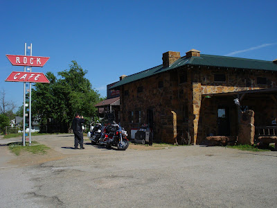
The day started warm and with a lite wind. By afternoon the winds had picked up to gusts of 30mph, which made the ride through Oklahoma City interesting to say the least. But we did stop at the Rock Cafe in Stroud, OK which has reopened after a fire of two years ago. Stroud is a dry county so no cold beer. We reached a high of 91F for the day.
We had a brief stop in Arcadia, OK at the Round Barn. The large red bar has great architectural features and has been fully restored. A great display of the history of the round barns in the area and this restoration was on the first floor of the barn.
As the wind was making the trip less pleasant as the day wore on we hopped on the Interstate to bypass Oklahoma City, and returned to Route 66 on the West side of the City.
Friday, May 7, 2010
Day 5 - Wed May 5 2010 - Rolla, MO - Miami, OK
After departing from Rolla we followed the old 4 lane divided Route 66 highway passing through the scenic rolling countryside. We bypassed both Springfield and Joplin, MO, using the I-40 for about 10miles to reduce the stop and go traffic and construction. Road construction was everywhere and was a pain!!
We went through the 12 miles of Route 66 in Kansas stopping at the old railroad station in Galena, KS which is now a Historical Museum. The long and very warm day ended about 6:30pm in Miami, at the Hampton Inn.
Day 4 - Tue May 4 2010 - Litchfield, IL - Rolla, MO
As we departed Litchfield the air temp was about 60f, by days end it was in the low 80's. As we departed Litchfield, IL, there was a stop at the Ariston Restaurant on the 1935-1965 alignment of Route 66 it is closed on Monday, so we never have been inside yet in two tries.
Our next stop is the Chain of Rocks Bridge linking Illinois and Missouri. This crossing the Mississippi is the separator of East and West of the United States. The Chain of Rocks Bridge is unique as it has a bend in the middle, so it is not a straight line between the two shores. This is a good link to explain the bridge and the 22 degree bend in the middle. http://en.wikipedia.org/wiki/Chain_of_Rocks_Bridge Note: When visiting the bridge I advise parking on the Illinois side of bridge rather than the Missouri side. If parking on Missouri side of bridge remove all valuables from your vehicle. On Motorcycle leave someone to guard the bikes (take turns). This parking lot has one of highest vehicle break-in rates in the city. Another advantage of parking on the Illinois side is the close proximity to alternate river side viewing lot. We spent a good hour checking out the bridge and walking to the the 22 degree bend.
After a rest for lunch it was time to hit the road for Rolla, we followed the old Route 66 through several towns: Pacific, St. Clair, Cuba, and St. James. We reached Rolla around 5:30pm in clear skies.
Day 3 - Mon May 3 2010 - Dwight, IL to Litchfield, IL
The weather was great riding weather - Sunny, and no wind for once. Our first stop was the Dwight Railroad Station which is on the old GM&O line and has several Amtrak trains. Just south of Dwight is the town of Odell, and the site of the historic Standard Oil Service Station from 1930. After several photos of our motorcycles lined up it was off again on the old road.
Our lunch stop today was in the town of Atlanta, with some fantastic murals on the sides of buildings, all very 30's style and just classic. Lunch was in the Plum Cafe (same spot as last year) on Arch Street next to the towns museum, a very friendly place and one well worth the stop on Route 66. As well Atlanta is the mid way point between Chicago and St. Louis on Route 66.
Tuesday, May 4, 2010
Day 2 - Sun May 2 2010 - Bryan, OH to Dwight, IL
A day of rain and sunny brakes, we departed from our motel in Bryan at 8:30 - on time I may add. There was a 50's style diner about 1km away and it was a very good choice for breakfast, so if you visit Bryan the name is Lestor's Dinner. (http://www.lestersonline.com/). What was different this year is only 25% full - where did the people go. We found out that the US economy is very bad and no one has money for restaurants.
We skipped Chicago as the starting point as we did last year, the roads and traffic are just so bad. So this year we started at the Route 66 Joliet Historical Museum.
Joliet impressed us last year, so why not make it the start of this years trip. We stopped at a Route 66 Tourist Trap called the Gemini Giant which is outside the Launching Pad drive-in. The fiberglass astronaut stands 28 feet tall and weighs 500 pounds. See a photo in the photo section.
We made it to our Hotel in Dwight at 6pm, after a tiring day on the road. Again only 4 rooms taken for the night in a Motel 6!!
Day 1 - Sat May 1 2010 - Niagara to Bryan, OH
We finally got underway on the great journey from Niagara a bit latter than planed - 9:45, same as last year. The same issues as last year too much "stuff", so had to part with some equipment which was not needed for the trip.
The real fun of the day was changing into rain gear at the side of I-90 near the PA/OH state line and battling high winds from time to time as well.
We reached our hotel in Bryan, OH around 6:20pm so that was good, but it was a long day on the bikes and for me my first long trip for the season as well.
Thursday, April 29, 2010
Welcome to the 2010 Journey on Route 66
This BLOG is about a great adventure to tour US Route 66 by motorcycle from Chicago to California in May 2010.
Subscribe to:
Posts (Atom)